| this button will popup a window from which you can save the track as a file.gpx for uploading to your GPS. |
Re: Florida state high point
Red tick marks show USGS 3m DEM cells with elevations of 345' or higher. 3m data is usually based on LiDAR surveys. Digital high point is 345.8' at 30.98483 -86.28238, about 0.1 miles SW of roadside monument (341'). Mouse-over the tick marks to see elevation values.
 The older (photogrammetric) 10m DEM quad-based data (Paxton quad) shows 8
high point cells of 347.1'
just south (30.98831 -86.28182) of the unnamed triangular benchmark.
The older 10m DEM from the seamless server shows one high point
of 347.1' in the same area at 30.98829 -86.28181
The newer 3m elevation data for that area shows 339'.
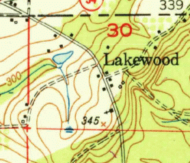
The 1950 15' Laurel Hill top at right shows a spot elevation of 345'
in the area of the LiDAR digital high point.
The other 340-contour 0.5 miles to the SW has a 3m-DEM digital high point of 339.7' at 30.97906 -86.28886.
You can paste lat,lon values into the Find box above to center the map at the lat,lon value. And you can center the map cross-hair on a point that interests you and then click the "elevation" URL at the base of the map, and it will report the USGS elevation for that point.
See Andy Hatzos lidar study and cohp trip report.
USGS current and historic topo maps
☹ Sadly, the microsoft terraserver (MSTopo) USGS topo map server is no longer active. The MSTopo had a higher resolution topo and was the base layer for the google map above. To zoom in try selecting the ArcGIS topo base map.
The grid of elevation points is based on older generations (e.g., 2009) of USGS 10M DEM data. See naionalmap elevation data.
Other Google maps arches falls GSMNP BSF towers AT shelters TN county high points Oak Ridge greenways
visits since 5/1/09