| this button will popup a window from which you can save the track as a file.gpx for uploading to your GPS. |
DEM overlay of sinkholes
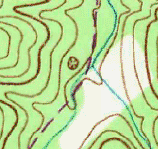
Map above shows 10m-DEM elevation ticks overlaid on deep sink hole
CAS001.
And nearby is smaller sinkhole
to NE, and tiny sinkhole to NW.
Mouseover ticks to read elevations.
The DEM says the low point of the deep sinkhole is 1195.4' at
36.410046,-83.942546.
The spill lip is found by inspection, probably 1315.5' at
36.409769,-83.940787.
The ArcMap digital analysis for this sinkhole reports:
Area: 0.05 km2
Perimeter: 1.11 km
Depth: 36.3 m
Volume: 78872 m3
Low: 364.8 m
High: 401 m
The topo map and the 10m DEM data can show the tiniest sinkhole, a single cell whose depth is less than all 8 of its bordering cells. Here is the single-cell sinkhole on Sinkhole Creek.
 |
757.60 750.59 745.05 741.40 739.26 758.09 750.45 745.02 742.35 740.62 759.26 750.43 742.30 738.93 740.34 762.10 754.88 747.74 743.43 743.78 766.63 761.02 756.36 752.71 750.08 |
Deep sinkholes are not obvious on topos with 40' contours, see COS001
see Tennessee sinkholes
☹ Sadly, the microsoft terraserver (MSTopo) USGS topo map server is no longer active. The MSTopo had a higher resolution topo and was the base layer for the google map above. To zoom in try selecting the ArcGIS topo base map.
The grid of elevation points is based on older generations (e.g., 2009) of USGS 10M DEM data. See naionalmap elevation data.
Other Google maps arches falls GSMNP BSF towers AT shelters TN county high points Oak Ridge greenways
visits since 5/1/09