Tennessee Landforms Google map
right click to add draggable markers iPhone map
marker:
Enter street,city,state or zip code or lat,-lon (dd.ddd)
(for lat/lon or UTM or NAD27 use this)
Distance buttons:
click on map to make a track (right-click to add draggable markers)
this button will popup a window from which you can save the track as a
file.gpx for uploading to your GPS.
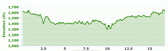
A 17-mile figure-8 loop starting on Divide Rd, then down to Rock Creek
trailhead. Mostly single-track with about 5 miles of gravel and
a 1100' cumulative climb.