Tennessee Landforms Google map
right click to add draggable markers iPhone map
marker:
Enter street,city,state or zip code or lat,-lon (dd.ddd)
(for lat/lon or UTM or NAD27 use this)
Distance buttons:
click on map to make a track (right-click to add draggable markers)
this button will popup a window from which you can save the track as a
file.gpx for uploading to your GPS.
Loyston Point
Located along the shore of
Norris Lake, the
Loyston Point mountain biking trails were constructed by TVA in 2014.
Mill Creek trail was added in 2016 (News-Sentinel
article).
Clinch River loop trail was added in 2021.
The trails roll through open forest atop fast-draining karstic terrain.
The area is managed by TWRA, so check the hunting schedules and obey the rules.
Trail
Miles
Description
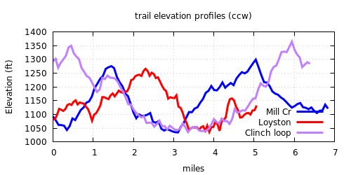
Loyston loop
5.4
cumulative climb 600' •
Mill Creek loop
7.3
bumps and berms, climb 660' •
Point 19
1.5
double-track to lake
Clinch
0.9
Clinch River loop
6.7
new 2022, climb 750' •
Hemlock Bluff
2.5
foot traffic only •
More info
Hemlock Bluff hike, 6 miles,
GPS track
and elevation profile

 Tennessee landforms
GSMNP landforms
BSF landforms
AT shelters
Tennessee landforms
GSMNP landforms
BSF landforms
AT shelters