 NOAA weather near waypoint
or
wunderground
NOAA weather near waypoint
or
wunderground
| WGS84 | |
| 36.469600 | -84.659000 |
| 36° 28.176'N | 84° 39.54'W |
| 36° 28' 10.6"N | 84° 39' 32.4"W |
| 16S 709748E 4038584N | |
| convert to NAD27 | |
MAPS
Select one of the following maps to display this waypoint (WGS84).
NOAA weather near waypoint
or
wunderground
GPS
Remarks:
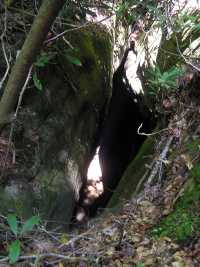
manway to this cleft in the caprock. Look into the cave through the skylights up top, or scramble down to the base.
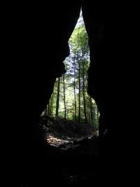
Chuck Sutherland's stunning photo