Appalachian Trail Shelters| WGS84 |
| 35.06997 | -83.49815 |
| 35° 4.198'N | 83° 29.889'W |
| 35° 4' 11.9"N | 83° 29' 53.3"W |
| 17S 272208E 3883657N |
| convert to NAD27 |
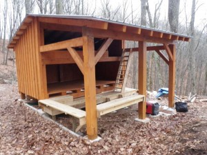
Long Branch Shelter 
Waypoint: LongBr 35.06997,-83.49815
County/State: Macon NC
Elevation: 4437' or USGS elevation
102.4 miles from Springer and 2095 miles to Katahdin
next shelter south ↓ 8.7 miles. next shelter north ↑ 3.4 miles. all shelters
popup list of
nearby shelters (mileage, bearing) (as the crow flies)
 NOAA weather near shelter
or
wunderground
NOAA weather near shelter
or
wunderground
MAPS
Select one of the following maps to display this waypoint (WGS84).

GPS
These maps, coordinates, and waypoint files are based on recent (2009)
Appalachian Trail
waypoints.
You can often find more information on a particular
shelter by visiting the AT
partners that maintains that section of trail.
For trail mileages between shelters go back to our
list of shelters.
AppalachianTrail.org has
the latest trail conditions, maps, and trail guides.
Additional information:
| Type: Shelter | Capacity: 8 | Fee: No |
| Near AT: Yes | Accuracy: GPS | Information: None |
| USFS Land: Yes | Maintained by: Nantahala Hiking Club |
Notes:
USGS quad: RAINBOW SPRINGS
new in 2012, more info
AT shelters
GSMNP campsites
GSMNP landforms
BSF landforms
TN landforms
 ©
Tom Dunigan TNlandforms.US
©
Tom Dunigan TNlandforms.US