Appalachian Trail Shelters| WGS84 |
| 36.71535 | -81.50951 |
| 36° 42.921'N | 81° 30.571'W |
| 36° 42' 55.3"N | 81° 30' 34.3"W |
| 17S 454496E 4063418N |
| convert to NAD27 |
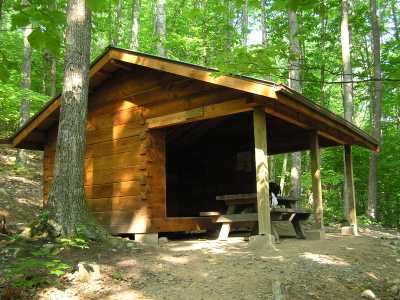
Hurricane Mountain Shelter 
Waypoint: Hurricane 36.71535,-81.50951
County/State: Grayson VA
Elevation: 3850' or USGS elevation
515.4 miles from Springer and 1682 miles to Katahdin
next shelter south ↓ 4.9 miles. next shelter north ↑ 9.2 miles. all shelters
popup list of
nearby shelters (mileage, bearing) (as the crow flies)
 NOAA weather near shelter
or
wunderground
NOAA weather near shelter
or
wunderground
MAPS
Select one of the following maps to display this waypoint (WGS84).

GPS
These maps, coordinates, and waypoint files are based on recent (2009)
Appalachian Trail
waypoints.
You can often find more information on a particular
shelter by visiting the AT
partners that maintains that section of trail.
For trail mileages between shelters go back to our
list of shelters.
AppalachianTrail.org has
the latest trail conditions, maps, and trail guides.
Additional information:
Notes: "Water south of trail"
USGS quad: WHITETOP MT
Δ elevation profile to next shelter north, cumulative climb/descent, (data provenance)
Hurricane Mountain Shelter (May, 2004) located 5.0 miles north of Old Orchard Shelter and
5.2 miles south of Dickey Gap or
10.2 miles south of Trimpi Shelter. The water source is a nearby stream; the shelter has a moldering privy.
AT shelters
GSMNP campsites
GSMNP landforms
BSF landforms
TN landforms
 ©
Tom Dunigan TNlandforms.US
©
Tom Dunigan TNlandforms.US