Appalachian Trail Shelters| WGS84 |
| 40.78249 | -75.61793 |
| 40° 46.949'N | 75° 37.076'W |
| 40° 46' 56.9"N | 75° 37' 4.6"W |
| 18T 447861E 4514795N |
| convert to NAD27 |
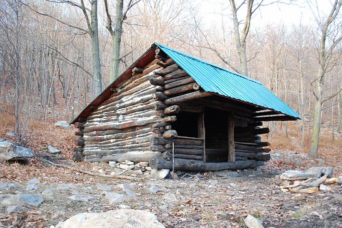
George W. Outerbridge Shelter 
Waypoint: GeorgeW 40.78249,-75.61793
County/State: Lehigh PA
Elevation: 1000' or USGS elevation
1260.3 miles from Springer and 937.1 miles to Katahdin
next shelter south ↓ 7.5 miles. next shelter north ↑ 17.0 miles. all shelters
popup list of
nearby shelters (mileage, bearing) (as the crow flies)
 NOAA weather near shelter
or
wunderground
NOAA weather near shelter
or
wunderground
MAPS
Select one of the following maps to display this waypoint (WGS84).

GPS
These maps, coordinates, and waypoint files are based on recent (2009)
Appalachian Trail
waypoints.
You can often find more information on a particular
shelter by visiting the AT
partners that maintains that section of trail.
For trail mileages between shelters go back to our
list of shelters.
AppalachianTrail.org has
the latest trail conditions, maps, and trail guides.
Additional information:
| Type: Shelter | Capacity: 6 | Fee: No |
| Near AT: Yes | Accuracy: GPS | Information: Near Palmerton Zinc plant; water bad |
| USFS Land: No | Maintained by: Allentown Hiking Club |
Notes: "AT passes shelter on W side of trail; AT passes piped spring in 105 yds--gb, 83"
USGS quad: PALMERTON
Δ elevation profile to next shelter north, cumulative climb/descent, (data provenance)
photo
AT shelters
GSMNP campsites
GSMNP landforms
BSF landforms
TN landforms
 ©
Tom Dunigan TNlandforms.US
©
Tom Dunigan TNlandforms.US