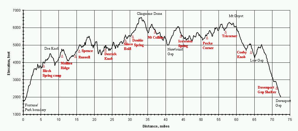
The AT runs 72.371 miles in the Great Smoky Mountain National Park. The cumulative climb from Fontana to Davenport Gap is about 20,000 feet (about 278 feet per mile). The mileage profile below is based on Robert Lochbaum's wheel-measured trail data (2007). Bob's data is also used in the "brown book", Hiking Trails of the Smokies. (GPS track distance with elevation adjustment: 71.913 miles. GPS distance is typically shorter due to discretization error.)
Mile elevation  Feature
 0     1727     Fontana/GSMNP boundary      AT mile 164.4
 0.7   1890     Lakeshore Trail
 4.0            Shuckstack
 4.4   3670     Lost Cove Trail/Sasafras Gap/Twentymile Trail
 5.3   3663     BC113 Birch Spring campsite
 7.5   4466     Gregory Bald Trail
 7.6            Doe Knob
 9.0   3842     Ekaneetlee Gap    lowest gap on Smokies crest
10.7   4570     Mollies Ridge Shelter
10.9            Devils Tater Patch
12.8   4089     Big Abrams Gap
13.9   4360     Russell Field Shelter/Trail
16.0            Mt Squires
16.8   4915     Spence Field Shelter/Eagle Creek Trail/Bote Mtn Trail
17.1   4930     Jenkins Ridge Trail
17.9            Rocky Top
18.6   5527     Thunderhead
21.2   4527     Starkey Gap
22.0            Sugartree Gap
23.0   4880     Derrick Knob Shelter
23.3   4770     Greenbrier Ridge Trail
25.4            Cold Spring Knob
25.7   4951     Miry Ridge Trail
25.9            Buckeye Gap
28.6   5460     Silers Bald Shelter
28.8            Silers Bald
29.0   5432     Welch Ridge Trail
30.3   5505     Double Spring Shelter
30.9   5756     Goshen Prong Trail
32.8   6517     Clingmans Dome bypass Trail
33.1            Clingmans Dome Trail
33.2   6643     Clingmans Dome
35.2            Collins Gap
36.2            Mt Collins
36.3   5962     Sugarlands Mtn Trail
36.5   5870     Mt Collins Shelter
36.6   5888     Fork Ridge Trail
39.3   5258     Indian Gap/Road Prong Trail
41.0   5022     Newfound Gap          AT mile 204.7
42.7   5817     Sweat Heifer Trail
43.5            Mt Ambler
43.7   6034     Boulevard Trail
44.1   5920     Icewater Spring Shelter
45.5   5401     Dry Sluice Trail
47.6   5221     False Gap
49.1            Laurel Top
51.5   5280     Hughes Ridge Trail/Pecks Corner Shelter
52.4            Eagle Rocks
54.3            Mt Sequoyah
55.9            Mt Chapman
56.7   5920     Tricorner Shelter/Balsam Mt Trail
58.0            Mt Guyot
59.0            Old Black
60.5   5788     Snake Den Ridge Trail
62.8   4688     Camel Gap Trail
64.0            Cosby Knob
64.4   4740     Cosby Knob Shelter
65.1   4242     Low Gap Trail
67.2   4963     Mt Cammerer Trail
69.5   3465     Lower Mt Cammerer Trail
70.4   2879     Chestnut Branch Trail
71.5   2600     Davenport Gap Shelter
72.4   2003     Davenport Gap              AT mile 236.0
Also see AT trail elevation profiles or shelter elevation profile and Smoky Mountain trails elevation profiles. You can draw tracks and get elevation profiles using the AT google map or the GSMNP google map.
The highest point on the AT is 6613' just NE of Clingman's Dome at Smokies mile 32.9 (35.56313 -83.49799).
Running the crest: 2009 and 2011
 with elevation profiles between shelters based on this
elevation data
with elevation profiles between shelters based on this
elevation data
AT lat,lon,elevation data from USGS DEM
GSMNP clickable trail map
GSMNP landforms and campsites
maps and GPS waypoints
clickable Google GSMNP map/topo with
campsites/landforms/trails (2007 data)
2012 Smokies GPS elevation survey TN/NC
LiDAR
Cumberland Trail elevation profiles