Tennessee lookout towers | WGS84 |
| 36.2612 | -83.7996 |
| 36° 15.672'N | 83° 47.976'W |
| 36° 15' 40.3"N | 83° 47' 58.6"W |
| 17S 248483E 4016556N |
| convert to NAD27 |
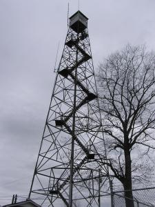
Maynardville
Waypoint: UNT003 36.2612,-83.7996
County: Union
Elevation: 1722'
Info: GA3562 2-11 standing
popup list of
nearby towers (mileage, bearing)
or
nearby landforms
MAPS
Select one of the following maps to display this waypoint (WGS84).
GPS
Remarks:
relocated from
Walker Ford.
Tennessee lookout towers

BSF landforms (TN/KY)
GSMNP landforms (TN/NC)
Tennessee landforms
home
arches
waterfalls
rocks
peaks
balds
sinks
lakes
regions
county
 ©
Tom Dunigan
©
Tom Dunigan