Tennessee lookout towers | WGS84 |
| 36.37211 | -83.89328 |
| 36° 22.327'N | 83° 53.597'W |
| 36° 22' 19.6"N | 83° 53' 35.8"W |
| 17S 240433E 4029111N |
| convert to NAD27 |
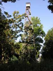
Chuck Swan
Waypoint: UNT001 36.37211,-83.89328
County: Union
Elevation: 1674'
Info: GA3565 2-10 standing
popup list of
nearby towers (mileage, bearing)
or
nearby landforms
MAPS
Select one of the following maps to display this waypoint (WGS84).
GPS
Remarks:
TWRA WMA.
Tennessee lookout towers

BSF landforms (TN/KY)
GSMNP landforms (TN/NC)
Tennessee landforms
home
arches
waterfalls
rocks
peaks
balds
sinks
lakes
regions
county
 ©
Tom Dunigan
©
Tom Dunigan