Tennessee lookout towers | WGS84 |
| 35.8121 | -83.6669 |
| 35° 48.726'N | 83° 40.014'W |
| 35° 48' 43.6"N | 83° 40' 0.8"W |
| 17S 259042E 3966391N |
| convert to NAD27 |
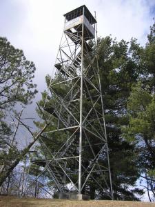
Bluff Mountain
Waypoint: SVT006 35.8121,-83.6669
County: Sevier
Elevation: 3069'
Info: FB2630 2-1 standing
popup list of
nearby towers (mileage, bearing)
or
nearby landforms
MAPS
Select one of the following maps to display this waypoint (WGS84).
GPS
Remarks:
Also known as Greentop, see
Ducth Roth 1940
black & white
Is it the same Bluff Mountain tower? There used to be one in VA.
Tennessee lookout towers

BSF landforms (TN/KY)
GSMNP landforms (TN/NC)
Tennessee landforms
home
arches
waterfalls
rocks
peaks
balds
sinks
lakes
regions
county
 ©
Tom Dunigan
©
Tom Dunigan