Tennessee lookout towers | WGS84 |
| 35.5293 | -85.4925 |
| 35° 31.758'N | 85° 29.55'W |
| 35° 31' 45.5"N | 85° 29' 33"W |
| 16S 636675E 3932788N |
| convert to NAD27 |
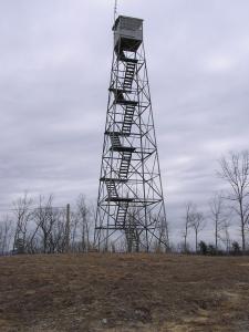
Jakes Mountain
Waypoint: SQT005 35.5293,-85.4925
County: Sequatchie
Elevation: 2204'
Info: standing
popup list of
nearby towers (mileage, bearing)
or
nearby landforms
MAPS
Select one of the following maps to display this waypoint (WGS84).
GPS
Remarks:
relocated from Bowater.
Tennessee lookout towers

BSF landforms (TN/KY)
GSMNP landforms (TN/NC)
Tennessee landforms
home
arches
waterfalls
rocks
peaks
balds
sinks
lakes
regions
county
 ©
Tom Dunigan
©
Tom Dunigan