Tennessee lookout towers | WGS84 |
| 35.4854 | -85.4694 |
| 35° 29.124'N | 85° 28.164'W |
| 35° 29' 7.4"N | 85° 28' 9.8"W |
| 16S 638845E 3927951N |
| convert to NAD27 |
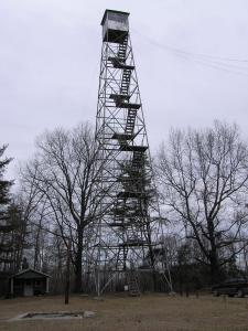
Wolfpen Mountain
Waypoint: SQT004 35.4854,-85.4694
County: Sequatchie
Elevation: 2244'
Info: 3-18 standing
popup list of
nearby towers (mileage, bearing)
or
nearby landforms
MAPS
Select one of the following maps to display this waypoint (WGS84).
GPS
Remarks:
also known as Cagle Tower, Tennessee's first fire tower,
see
historic photo.
NHLR
info
Tennessee lookout towers

BSF landforms (TN/KY)
GSMNP landforms (TN/NC)
Tennessee landforms
home
arches
waterfalls
rocks
peaks
balds
sinks
lakes
regions
county
 ©
Tom Dunigan
©
Tom Dunigan