Tennessee lookout towers | WGS84 |
| 35.7233 | -84.8593 |
| 35° 43.398'N | 84° 51.558'W |
| 35° 43' 23.9"N | 84° 51' 33.5"W |
| 16S 693622E 3955372N |
| convert to NAD27 |
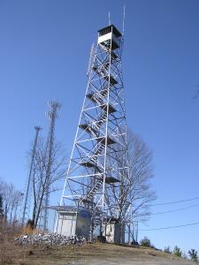
Grandview
Waypoint: RHT001 35.7233,-84.8593
County: Rhea
Elevation: 1499'
Info: 3-1 standing
popup list of
nearby towers (mileage, bearing)
or
nearby landforms
MAPS
Select one of the following maps to display this waypoint (WGS84).
GPS
Remarks:
Tennessee lookout towers

BSF landforms (TN/KY)
GSMNP landforms (TN/NC)
Tennessee landforms
home
arches
waterfalls
rocks
peaks
balds
sinks
lakes
regions
county
 ©
Tom Dunigan
©
Tom Dunigan