Tennessee lookout towers | WGS84 |
| 36.18699 | -84.6277 |
| 36° 11.219'N | 84° 37.662'W |
| 36° 11' 13.1"N | 84° 37' 39.7"W |
| 16S 713322E 4007298N |
| convert to NAD27 |
Pilot Mountain
Waypoint: MGT005 36.18699,-84.6277
County: Morgan
Elevation: 2510'
Info: GB2610 2-27 standing
popup list of
nearby towers (mileage, bearing)
or
nearby landforms
MAPS
Select one of the following maps to display this waypoint (WGS84).
GPS
Remarks:
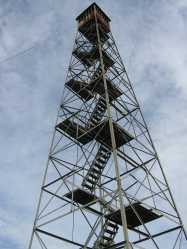 now Tennessee conservation area land
Tennessee lookout towers

BSF landforms (TN/KY)
GSMNP landforms (TN/NC)
Tennessee landforms
home
arches
waterfalls
rocks
peaks
balds
sinks
lakes
regions
county
 ©
Tom Dunigan
©
Tom Dunigan