Tennessee lookout towers | WGS84 |
| 35.32459 | -84.4526 |
| 35° 19.475'N | 84° 27.156'W |
| 35° 19' 28.5"N | 84° 27' 9.4"W |
| 16S 731558E 3912018N |
| convert to NAD27 |
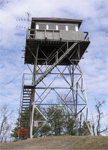
Starr Mountain
Waypoint: MCT002 35.32459,-84.4526
County: McMinn
Elevation: 2205'
Info: 3-4 standing
popup list of
nearby towers (mileage, bearing)
or
nearby landforms
MAPS
Select one of the following maps to display this waypoint (WGS84).
GPS
Remarks:
another photo of tower and history of
Starr Mountain
Tennessee lookout towers

BSF landforms (TN/KY)
GSMNP landforms (TN/NC)
Tennessee landforms
home
arches
waterfalls
rocks
peaks
balds
sinks
lakes
regions
county
 ©
Tom Dunigan
©
Tom Dunigan