Tennessee lookout towers | WGS84 |
| 35.5295 | -84.7185 |
| 35° 31.77'N | 84° 43.11'W |
| 35° 31' 46.2"N | 84° 43' 6.6"W |
| 16S 706859E 3934159N |
| convert to NAD27 |
McMinn Ridge
Waypoint: MCT001 35.5295,-84.7185
County: McMinn
Elevation: 1296'
Info: FC1817 3-3 standing
popup list of
nearby towers (mileage, bearing)
or
nearby landforms
MAPS
Select one of the following maps to display this waypoint (WGS84).
GPS
Remarks:
80' tower, active, Meigs county high point
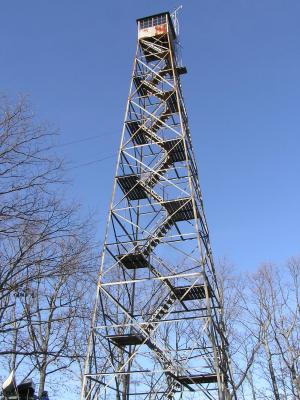
weather at the tower, Pone Knob.
Tom Owen's
photo
Tennessee lookout towers

BSF landforms (TN/KY)
GSMNP landforms (TN/NC)
Tennessee landforms
home
arches
waterfalls
rocks
peaks
balds
sinks
lakes
regions
county
 ©
Tom Dunigan
©
Tom Dunigan