Tennessee lookout towers | WGS84 |
| 36.0702 | -83.48829 |
| 36° 4.212'N | 83° 29.297'W |
| 36° 4' 12.7"N | 83° 29' 17.8"W |
| 17S 275913E 3994601N |
| convert to NAD27 |
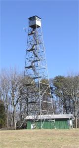
Jefferson City
Waypoint: JET001 36.0702,-83.48829
County: Jefferson
Elevation: 1732'
Info: 1-7 standing
popup list of
nearby towers (mileage, bearing)
or
nearby landforms
MAPS
Select one of the following maps to display this waypoint (WGS84).
GPS
Remarks:
Tennessee lookout towers

BSF landforms (TN/KY)
GSMNP landforms (TN/NC)
Tennessee landforms
home
arches
waterfalls
rocks
peaks
balds
sinks
lakes
regions
county
 ©
Tom Dunigan
©
Tom Dunigan