Tennessee lookout towers | WGS84 |
| 35.03779 | -88.2315 |
| 35° 2.267'N | 88° 13.89'W |
| 35° 2' 16"N | 88° 13' 53.4"W |
| 16S 387672E 3877928N |
| convert to NAD27 |
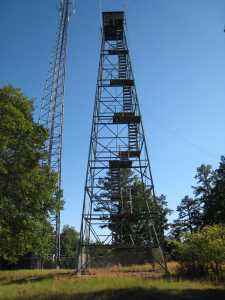
Turkey Knob
Waypoint: HDT004 35.03779,-88.2315
County: Hardin
Elevation: 673'
Info: FE2249 7-29 standing
popup list of
nearby towers (mileage, bearing)
or
nearby landforms
MAPS
Select one of the following maps to display this waypoint (WGS84).
GPS
Remarks:
Tennessee lookout towers

BSF landforms (TN/KY)
GSMNP landforms (TN/NC)
Tennessee landforms
home
arches
waterfalls
rocks
peaks
balds
sinks
lakes
regions
county
 ©
Tom Dunigan
©
Tom Dunigan