Tennessee lookout towers | WGS84 |
| 36.5235 | -84.7747 |
| 36° 31.41'N | 84° 46.482'W |
| 36° 31' 24.6"N | 84° 46' 28.9"W |
| 16S 699242E 4044318N |
| convert to NAD27 |
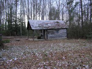
Rock House
Waypoint: FET005 36.5235,-84.7747
County: Fentress
Elevation: 1687'
Info: GB2639 4-1 moved
popup list of
nearby towers (mileage, bearing)
or
nearby landforms
MAPS
Select one of the following maps to display this waypoint (WGS84).
GPS
Remarks:
only cement footings remain and ye ol cabin, the tower was moved
to Pickett in 1972
Tennessee lookout towers

BSF landforms (TN/KY)
GSMNP landforms (TN/NC)
Tennessee landforms
home
arches
waterfalls
rocks
peaks
balds
sinks
lakes
regions
county
 ©
Tom Dunigan
©
Tom Dunigan