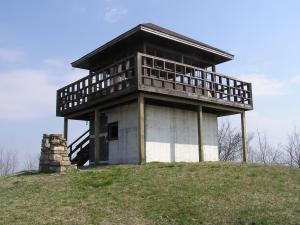
 converted to platform in 2012.
| WGS84 | |
| 35.9715 | -82.9705 |
| 35° 58.29'N | 82° 58.23'W |
| 35° 58' 17.4"N | 82° 58' 13.8"W |
| 17S 322329E 3982582N | |
| convert to NAD27 | |
MAPS
Select one of the following maps to display this waypoint (WGS84).
GPS
Remarks:
From Cherokee National Forest Hiking Guide: "The current tower is the fifth to stand on the site. In 1926, the tower was nothing more than a platform between three chestnut trees with a small tent. This tent office housed a hand-crank telephone that was used to send news of fires that had been spotted. "
converted to platform in 2012.