Tennessee lookout towers | WGS84 |
| 35.8648 | -83.1435 |
| 35° 51.888'N | 83° 8.61'W |
| 35° 51' 53.3"N | 83° 8' 36.6"W |
| 17S 306468E 3971074N |
| convert to NAD27 |
Hall Top
Waypoint: COT002 35.8648,-83.1435
County: Cocke
Elevation: 3610'
Info: FB2442 1-2 standing
popup list of
nearby towers (mileage, bearing)
or
nearby landforms
MAPS
Select one of the following maps to display this waypoint (WGS84).
GPS
Remarks:
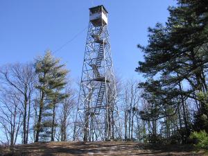
Dutch Roth 1936
black & white
Tennessee lookout towers

BSF landforms (TN/KY)
GSMNP landforms (TN/NC)
Tennessee landforms
home
arches
waterfalls
rocks
peaks
balds
sinks
lakes
regions
county
 ©
Tom Dunigan
©
Tom Dunigan