Tennessee lookout towers | WGS84 |
| 36.3573 | -84.1421 |
| 36° 21.438'N | 84° 8.526'W |
| 36° 21' 26.3"N | 84° 8' 31.6"W |
| 16S 756441E 4027373N |
| convert to NAD27 |
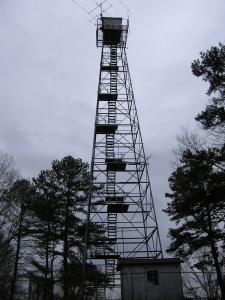
Lafollette
Waypoint: CAT003 36.3573,-84.1421
County: Campbell
Elevation: 1240'
Info: standing
popup list of
nearby towers (mileage, bearing)
or
nearby landforms
MAPS
Select one of the following maps to display this waypoint (WGS84).
GPS
Remarks:
relocated from Cline Knob,
reference Ron Stafford
Tennessee lookout towers

BSF landforms (TN/KY)
GSMNP landforms (TN/NC)
Tennessee landforms
home
arches
waterfalls
rocks
peaks
balds
sinks
lakes
regions
county
 ©
Tom Dunigan
©
Tom Dunigan