Tennessee lookout towers | WGS84 |
| 36.2597 | -84.1011 |
| 36° 15.582'N | 84° 6.066'W |
| 36° 15' 34.9"N | 84° 6' 4"W |
| 16S 760445E 4016652N |
| convert to NAD27 |
Cove Creek
Waypoint: CAT002 36.2597,-84.1011
County: Campbell
Elevation: 1450'
Info: 2-15 standing
popup list of
nearby towers (mileage, bearing)
or
nearby landforms
MAPS
Select one of the following maps to display this waypoint (WGS84).
GPS
Remarks:
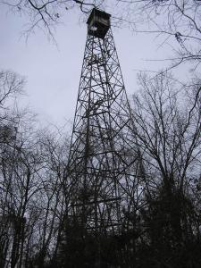 aka, Norris
Tennessee lookout towers

BSF landforms (TN/KY)
GSMNP landforms (TN/NC)
Tennessee landforms
home
arches
waterfalls
rocks
peaks
balds
sinks
lakes
regions
county
 ©
Tom Dunigan
©
Tom Dunigan