Tennessee lookout towers | WGS84 |
| 35.76509 | -83.7585 |
| 35° 45.905'N | 83° 45.51'W |
| 35° 45' 54.3"N | 83° 45' 30.6"W |
| 17S 250617E 3961405N |
| convert to NAD27 |
Millstone Gap
Waypoint: BTT003 35.76509,-83.7585
County: Blount
Elevation: 2843'
Info: FB2649 2-2 standing
popup list of
nearby towers (mileage, bearing)
or
nearby landforms
MAPS
Select one of the following maps to display this waypoint (WGS84).
GPS
Remarks:
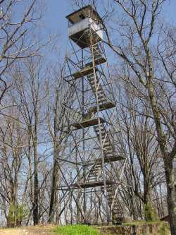
Blackberry Mountain resort, private
Tennessee lookout towers

BSF landforms (TN/KY)
GSMNP landforms (TN/NC)
Tennessee landforms
home
arches
waterfalls
rocks
peaks
balds
sinks
lakes
regions
county
 ©
Tom Dunigan
©
Tom Dunigan