Tennessee lookout towers | WGS84 |
| 35.1565 | -84.9615 |
| 35° 9.39'N | 84° 57.69'W |
| 35° 9' 23.4"N | 84° 57' 41.4"W |
| 16S 685675E 3892301N |
| convert to NAD27 |
Nature Center
Waypoint: BRT003 35.1565,-84.9615
County: Bradley
Elevation: 850'
Info: sitting
popup list of
nearby towers (mileage, bearing)
or
nearby landforms
MAPS
Select one of the following maps to display this waypoint (WGS84).
GPS
Remarks:
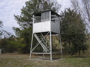
Ocoee Regional Nature Center
exhibit of top of former Ooltewah tower
(reference Ron Stafford)
Tennessee lookout towers

BSF landforms (TN/KY)
GSMNP landforms (TN/NC)
Tennessee landforms
home
arches
waterfalls
rocks
peaks
balds
sinks
lakes
regions
county
 ©
Tom Dunigan
©
Tom Dunigan