Tennessee lookout towers | WGS84 |
| 35.4415 | -85.2663 |
| 35° 26.49'N | 85° 15.978'W |
| 35° 26' 29.4"N | 85° 15' 58.7"W |
| 16S 657356E 3923386N |
| convert to NAD27 |
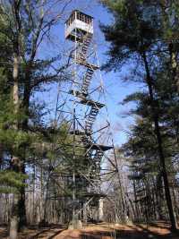
Hendon
Waypoint: BLT006 35.4415,-85.2663
County: Bledsoe
Elevation: 2319'
Info: 3-10 standing
popup list of
nearby towers (mileage, bearing)
or
nearby landforms
MAPS
Select one of the following maps to display this waypoint (WGS84).
GPS
Remarks:
Tennessee lookout towers

BSF landforms (TN/KY)
GSMNP landforms (TN/NC)
Tennessee landforms
home
arches
waterfalls
rocks
peaks
balds
sinks
lakes
regions
county
 ©
Tom Dunigan
©
Tom Dunigan