Tennessee lookout towers | WGS84 |
| 35.68849 | -85.0498 |
| 35° 41.309'N | 85° 2.988'W |
| 35° 41' 18.5"N | 85° 2' 59.3"W |
| 16S 676466E 3951152N |
| convert to NAD27 |
Worthington Knob
Waypoint: BLT004 35.68849,-85.0498
County: Bledsoe
Elevation: 2554'
Info: 3-7 standing
popup list of
nearby towers (mileage, bearing)
or
nearby landforms
MAPS
Select one of the following maps to display this waypoint (WGS84).
GPS
Remarks:
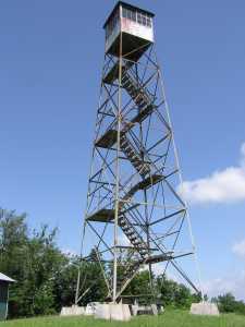 aka, Luminary
Tennessee lookout towers

BSF landforms (TN/KY)
GSMNP landforms (TN/NC)
Tennessee landforms
home
arches
waterfalls
rocks
peaks
balds
sinks
lakes
regions
county
 ©
Tom Dunigan
©
Tom Dunigan