Tennessee lookout towers | WGS84 |
| 36.11021 | -84.23051 |
| 36° 6.613'N | 84° 13.831'W |
| 36° 6' 36.8"N | 84° 13' 49.9"W |
| 16S 749290E 3999725N |
| convert to NAD27 |
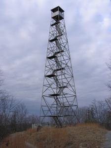
Laurel Grove
Waypoint: ANT002 36.11021,-84.23051
County: Anderson
Elevation: 1743'
Info: 2-16 standing
popup list of
nearby towers (mileage, bearing)
or
nearby landforms
MAPS
Select one of the following maps to display this waypoint (WGS84).
GPS
Remarks:
more photos 11/7/15
Tennessee lookout towers

BSF landforms (TN/KY)
GSMNP landforms (TN/NC)
Tennessee landforms
home
arches
waterfalls
rocks
peaks
balds
sinks
lakes
regions
county
 ©
Tom Dunigan
©
Tom Dunigan