Tennessee lookout towers | WGS84 |
| 36.13975 | -84.06383 |
| 36° 8.385'N | 84° 3.83'W |
| 36° 8' 23.1"N | 84° 3' 49.8"W |
| 16S 764198E 4003443N |
| convert to NAD27 |
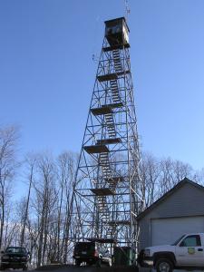
Bluebird
Waypoint: ANT001 36.13975,-84.06383
County: Anderson
Elevation: 1319'
Info: GB2537 2-17 standing
popup list of
nearby towers (mileage, bearing)
or
nearby landforms
MAPS
Select one of the following maps to display this waypoint (WGS84).
GPS
Remarks:
weather at the tower
Tennessee lookout towers

BSF landforms (TN/KY)
GSMNP landforms (TN/NC)
Tennessee landforms
home
arches
waterfalls
rocks
peaks
balds
sinks
lakes
regions
county
 ©
Tom Dunigan
©
Tom Dunigan