Bicycles are not permitted on foot trails, and the area is closed for hunts at various times in the spring and fall. Contact the WMA manager (423-658-9201) for closure dates. See WMA fall hunt schedules. WMA is closed for deer hunts at various times during the fall, see TWRA hunt schedules for April and May closure dates for turkey hunts also see TWRA WMA hunt schedule.
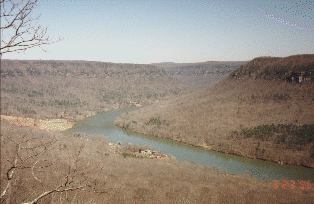
Description: The Prentice Cooper State Forest and Wildlife Management Area occupies 24,000 acres on the Cumberland Plateau. The eastern face has sheer bluffs (1000') above the Tennessee River, The central portion is carved out by Mullens Creek, and the western boundary is not quite as sheer, with jeep road access from TN27. The main forest road, Tower Drive, (12 miles) is wide, packed gravel and fairly level. A fire tower (1920') is located at mile 4. There are numerous roads looping off Tower Drive, as well as spurs (Richy Pt, Pot Pt) to various overlooks ( picture, 50K) on the east side as well as rides along the bluffs. The major roads are named and marked at their intersection with Tower Drive. The roads are sandy (from the breakdown of the underlying sandstone) with an occasional touch of red clay. From Lusk Cemetery, you can ride East Brow road along the edge of the bluff, exiting back to Tower Drive via Ralley Ridge, Lusk Point, Sulphur Branch, or Braddison Branch.
Roads to the west of Tower Drive cross the Mullens Creek watershed and are steeper and wetter than the eastern roads. Haley Rd travels west 6.6 miles to TN 27. The first mile of Haley Rd is a gnarly descent to Mullens Cr and a wet crossing -- perhaps impassable at high water. West of Mullens Creek are southern spurs to Elder Point and Long Point, and just past Dry Creek, Inman Point's more southern overlooks. From Inman Point intersection (mile 4.7), Haley Rd descends the western escarpment 1.9 miles to TN27 0.4 miles south of Ketner Mill Rd. Persimmon Rd crosses Mullens Creek (1.4 mi 1480'), intersects with the dirt road (Marshall Fork Rd, 4.7 mi,1970') from Ketner Gap, and provides access to the more western jeep roads. You can reach the western rim in about 8 miles, climb to 2040', then descend to Haley Rd (10.5 mi, 1580') just west of Dry Creek. You can head back on Haley Rd 4.7 miles to Tower Drive. Here some GPS tracks.
A natural bridge is located north of Pot Point road along the Cumberland Trail.