Frozen Head
Distance: 6.6 miles (1 way)
Time: 2 hours (1 way)
Rating: Strenuous
Elevation: Campground 1360', fire tower 3324', 10% gradient
first 3 miles!(2-way cumulative climb: 2900')
Surface: dirt
Maps:
Fork Mtn. quadrangle (trail map available at visitor center)
trail map
topo map (80K)
3-D shaded topo map (88K)
park map
3-D view (33K)
Google map
CT Frozen Head
trail map
track and elevation profile
Access:
Located north of Highway 62 between Oliver Springs and Wartburg.
Park at the campground.
We have GPS waypoints (.gpx), maps, and driving directions for some of the
trail heads at trail-head parking.
Description:
Frozen Head State Park is nestled in 12,000 acres in the back of the valley
of the Flat Fork watershed.
Activities include hiking, biking, camping, backpacking, and picnicing.
It has some beautiful wild flower hikes in the Spring.
The gated jeep road to the fire tower is dirt and climbs through
a hardwood forest and several sandstone seams. The views from
the
fire tower (now,2007, a lower viewing platform) are spectacular, with the wilderness of the Cumberland
Mountains to the north and the Tennessee Valley to the south.
(Aso see the
history of the Park and Wikipedia
info.)
From the campground (1460'), ride past the gate on the jeep road at the end of
the campground and climb steadily (+1600') for 3 miles, then climb some more.
At mile 5 (3020'), the trail from Coffin Spring
comes in from the north.
At mile 6.2 (3080') the road to Armes Gap descends (2.2 mi) to the left,
and the road to the right climbs 0.4 miles to the fire tower (3324').
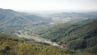
View from fire tower looking southeast
( picture 49K).
See
track and elevation profile.
An alternate trail to the fire tower starts at Armes Gap (2139') on Highway 116,
north of Petros. Park at the gap at the top of the ridge.
Lift over the gate, and climb 2.6 miles to the fire tower (1200' climb).
To the east of the gap, Park land includes the west face of Big Fodderstack.
 You can also hike to several waterfalls, see Frozen Head State Park
landforms from
landforms of Tennessee (GPS data and maps).
Hike the
Frozen Head section of the Cumberland Trail.
Or try your luck at the
Barkley 100 mile run or
NYT article.
GPS tracks of varioius Frozen Head hikes:
You can also hike to several waterfalls, see Frozen Head State Park
landforms from
landforms of Tennessee (GPS data and maps).
Hike the
Frozen Head section of the Cumberland Trail.
Or try your luck at the
Barkley 100 mile run or
NYT article.
GPS tracks of varioius Frozen Head hikes:
Spicewood and Old Mac
Ross Gap loop
North Bird Mtn
CT east frozen head
Castle Rock loop
 Tennessee lookout towers
Return to East Tennessee mountain bike rides.
©
Revised 12/23/95 by Tom Dunigan
epic ride Frozen Head to Caryville 1996