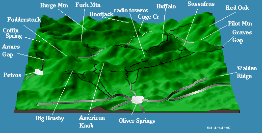
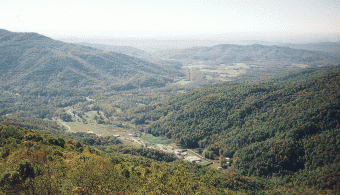
Description: The main access road for this area is the Fork Mountain haulroad that starts at the Moores Camp (Devonia) coal washer (1460') on highway 116. This gravel road climbs steeply for two miles up to a coal bench (2160') that circles the Indian Fork watershed. At mile 10.8 the road climbs to mile 11 (2790'), where there is a nice overlook into the Smoky Creek watershed to the north ( picture 49K). The gravel road below the overlook heads west to Guinea Gap (2900'), Gobey, and Brimstone. To the right the road leads to Burge Mountain, Bootjack Mountain, and Smoky Creek.
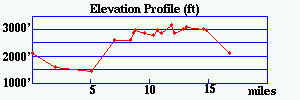
The Coffin Spring loop is a 17-mile loop (cumulative climb 2200') that starts at Armes Gap (2139') on 116. From the gap, descend (NE) 5 miles on 116 to the Moores Camp coal washer (1460'), turn left on the gravel Fork Mtn haulroad and climb steadily for two miles (mile 7.0, 2620'), continue following the gravel along the coal bench around the Indian Fork watershed. At mile 8.3 take the gravel to the left up to the top of Fork Mountain and continue north (3000') to the west face of the mountain and around the Stallion Branch watershed. At mile 10.4 (2800') take the right fork up and over Stallion Mtn. (The left fork descends 2.1 miles to 116.) Continue west along the 3000' bench and at mile 11.0 take the right fork up and eventually into the woods at 3200'. At about mile 11.8 (UTM 729.8 4003.65), the road bears right (N), take the single track to the left (SW) toward Coffin Spring. The single track turns back into an old road bed as it passes Coffin Spring (mile 12.1, 2900') and climbs to the intersection with the jeep road from Frozen Head campground (mile 12.8, 3050'). (To the the right, the campground is 5.1 miles down the mountain.) Turn left (S) on the jeep road and ride to the Tub Spring intersection (mile 14.5, 3050'). From here is a 0.4 mile climb to the fire tower (3324') with good views of the Cumberlands and the Tennessee Valley ( picture 49K). Turn left (E) at the Tub Spring intersection and descend 2.3 miles to Armes Gap. Below is an elevation profile for the loop.
There are other areas to explore in this portion of the Cumberlands. From the Smoky Creek overlook you can head east and take a right and descend a jeep road 4 miles down the Indian Fork watershed back to 116 about 0.7 miles from the coal washer. Or from the overlook, proceed east and north along the lower gravel into the Smoky Creek watershed to Smoky Junction on the New River. You can then head back south along the gravel road that follows the New River back to 116, and then west on 116 back to the coal washer (about a 34 mile loop).
For the more adventurous, east from the overlook and up to Grassy Gap, the dirt road heads 5 miles towards Bootjack Mtn and 116. The dirt road changes to an ATV track as it follows the top of Smoky Mountain to Bootjack. There is also a vertical ATV track that leaves the dirt road just before the power line and descends to the Cage Creek bench.
The Cage Creek loop (16.6 miles, cumulative climb of 1500') starts west of junction of 116 with the road to Shea (1330', northwest of the bridge) and climbs 1.8 miles (2150') where you turn left on a gravel road and follow the seam around the Cage Creek watershed, through Brier Gap (mile 10,2250'), then back north for a mile or so before descending to 116 at Rosedale School. It's 3.7 miles back to the bridge. (Before the descent there is a jeep road that climbs up to Burge Mountain and goes west 2.5 miles to the Smoky Creek road.)
If you follow the gravel (Brimstone haul road) 2.6 miles on northwest of Guinea Gap, Gobey road descends west 14 miles through the Emory River watershed to US27 north of Wartburg. Just west of the Gobey road, a jeep road leaves to the left that follows the ridge tops to the Pilot Mountain fire tower, 'bout 21 miles. (Much of this is private land, no ATVs.)
Continuing past that jeep road along the gravel, you pass the Brimstone Washer (2900'), and the gravel continues north offering at least two different descents down to the community of Slick Rock along Brimstone Creek. There is also a 32 mile ride from Huntsville to Frozen Head.