Tennessee Landforms -- waterfalls| WGS84 |
| 36.162340 | -82.463690 |
| 36° 9.74'N | 82° 27.821'W |
| 36° 9' 44.4"N | 82° 27' 49.3"W |
| 17S 368348E 4002947N |
| convert to NAD27 |
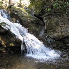
Savannah Falls 14'
Waypoint: WSF010 36.162340,-82.463690
County: Washington landforms of Washington county
Locale: Cherokee National Forest
popup list of
nearby landforms (mileage, bearing)
MAPS
Select one of the following maps to display this waypoint (WGS84).
GPS
Remarks:
Reference and photo: Dave Aldrige
Tennessee landforms
home
arches
waterfalls
rocks
peaks
balds
sinks
lakes
regions
county
GSMNP landforms (TN/NC)
BSF landforms (TN/KY)
or nearby
lookout towers
 ©
Tom Dunigan
©
Tom Dunigan