Tennessee Landforms -- waterfalls| WGS84 |
| 36.428740 | -82.631200 |
| 36° 25.724'N | 82° 37.872'W |
| 36° 25' 43.4"N | 82° 37' 52.3"W |
| 17S 353778E 4032740N |
| convert to NAD27 |
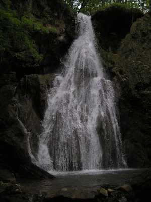
Fall Branch Falls 40'
Waypoint: WSF001 36.428740,-82.631200
County: Washington landforms of Washington county
Locale: private
popup list of
nearby landforms (mileage, bearing)
MAPS
Select one of the following maps to display this waypoint (WGS84).
GPS
Remarks:
Tennessee landforms
home
arches
waterfalls
rocks
peaks
balds
sinks
lakes
regions
county
GSMNP landforms (TN/NC)
BSF landforms (TN/KY)
or nearby
lookout towers
Chuck Sutherland's www.tnlandforms.com the future (2024)
 ©
Tom Dunigan
©
Tom Dunigan