Tennessee Landforms -- waterfalls| WGS84 |
| 35.839338 | -85.640105 |
| 35° 50.36'N | 85° 38.406'W |
| 35° 50' 21.6"N | 85° 38' 24.4"W |
| 16S 622816E 3966982N |
| convert to NAD27 |
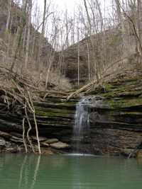
Hickory Nut Falls 30'
Waypoint: WHF024 35.839338,-85.640105
County: White landforms of White county
Locale: CenterHill
popup list of
nearby landforms (mileage, bearing)
MAPS
Select one of the following maps to display this waypoint (WGS84).
GPS
Remarks:
wet-weather falls
Tennessee landforms
home
arches
waterfalls
rocks
peaks
balds
sinks
lakes
regions
county
GSMNP landforms (TN/NC)
BSF landforms (TN/KY)
or nearby
lookout towers
 ©
Tom Dunigan
©
Tom Dunigan