Tennessee Landforms -- waterfalls| WGS84 |
| 35.907061 | -85.643545 |
| 35° 54.424'N | 85° 38.613'W |
| 35° 54' 25.4"N | 85° 38' 36.8"W |
| 16S 622401E 3974490N |
| convert to NAD27 |
Waterfalls Hollow Falls 50'
Waypoint: WHF017 35.907061,-85.643545
County: White landforms of White county
popup list of
nearby landforms (mileage, bearing)
MAPS
Select one of the following maps to display this waypoint (WGS84).
GPS
Remarks:
wet-weather falls, 500' from the lake shore
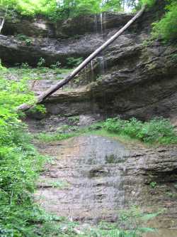
 further up Cedar Creek
(here) is a 15' falls, visible at low pool
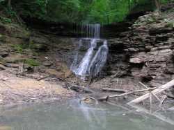
further up Cedar Creek
(here) is a 15' falls, visible at low pool
Tennessee landforms
home
arches
waterfalls
rocks
peaks
balds
sinks
lakes
regions
county
GSMNP landforms (TN/NC)
BSF landforms (TN/KY)
or nearby
lookout towers
 ©
Tom Dunigan
©
Tom Dunigan