| WGS84 | |
| 35.755780 | -85.444700 |
| 35° 45.347'N | 85° 26.682'W |
| 35° 45' 20.8"N | 85° 26' 40.9"W |
| 16S 640612E 3957977N | |
| convert to NAD27 | |
MAPS
Select one of the following maps to display this waypoint (WGS84).
GPS
Remarks:
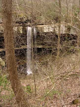
Reference & photo: Dwight Haston
Little Falls is owned
by the Van Buren County Schools.
The land was bought by
Mourice Taft, using his own funds. The land was used to
quarry building stone during the Depresion Era to build the
frist High School in the county. He then left the land in a
trust Fund in 1838 to the childern of Van Buren County with
the School Board to watch over it.
1938 photo
Maurice Taft aka Judge Taft- also bought a large land holding in Van Buren county and is credited with the concept and plan to construct Fall Creek Falls State Park. He is known as the " Father of Fall Creek Falls. This falls is 60 feet and is locaked on Millstone Branch and is open to hikers if they approach from a trail head at N35 45.294 W 85 25.998
Chuck Sutherland's photo1 or photo2