| WGS84 | |
| 36.300500 | -83.857200 |
| 36° 18.03'N | 83° 51.432'W |
| 36° 18' 1.8"N | 83° 51' 25.9"W |
| 17S 243436E 4021068N | |
| convert to NAD27 | |
MAPS
Select one of the following maps to display this waypoint (WGS84).
GPS
Remarks:
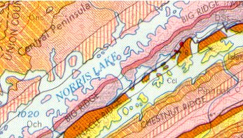
The red indicates the location of igneous rock (mica-peridotite). When Norris Lake is at full pool, much of the formation is submerged. (Norris current lake level) One of two igneous formations in TN, neither are visually significant.
More detailed map from Journal of Geology 1944 or superimposed on Google map and summary