Tennessee Landforms -- waterfalls| WGS84 |
| 36.061300 | -82.571400 |
| 36° 3.678'N | 82° 34.284'W |
| 36° 3' 40.7"N | 82° 34' 17"W |
| 17S 358478E 3991890N |
| convert to NAD27 |
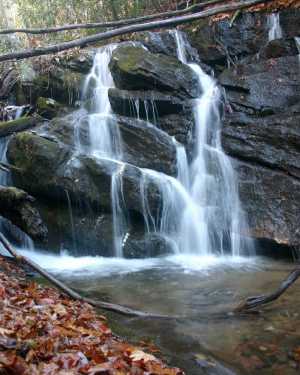
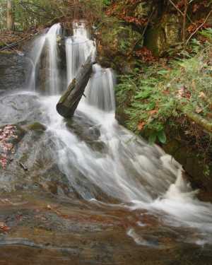
Long Branch Falls(2) 15'
Waypoint: UCF030 36.061300,-82.571400
County: Unicoi landforms of Unicoi county
Locale: private
popup list of
nearby landforms (mileage, bearing)
MAPS
Select one of the following maps to display this waypoint (WGS84).
GPS
Remarks:
Reference and photos: Bill Stowell
part of Rocky Fork watershed
Tennessee landforms
home
arches
waterfalls
rocks
peaks
balds
sinks
lakes
regions
county
GSMNP landforms (TN/NC)
BSF landforms (TN/KY)
or nearby
lookout towers
 ©
Tom Dunigan
©
Tom Dunigan