Tennessee Landforms -- waterfalls| WGS84 |
| 35.623900 | -83.642200 |
| 35° 37.434'N | 83° 38.532'W |
| 35° 37' 26"N | 83° 38' 31.9"W |
| 17S 260712E 3945450N |
| convert to NAD27 |
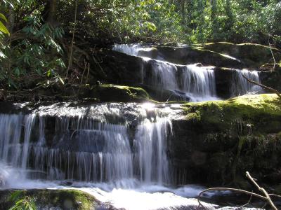
Marks Creek Falls 22'
Waypoint: SVF023 35.623900,-83.642200
County: Sevier landforms of Sevier county
Locale: Great Smoky Mountains National Park
popup list of
nearby landforms (mileage, bearing)
MAPS
Select one of the following maps to display this waypoint (WGS84).
GPS
Remarks:
off-trail, old railroad bed (see 1931 map above)
Tennessee landforms
home
arches
waterfalls
rocks
peaks
balds
sinks
lakes
regions
county
GSMNP landforms (TN/NC)
BSF landforms (TN/KY)
or nearby
lookout towers
 ©
Tom Dunigan
©
Tom Dunigan