Tennessee Landforms -- waterfalls| WGS84 |
| 35.660200 | -83.442100 |
| 35° 39.612'N | 83° 26.526'W |
| 35° 39' 36.7"N | 83° 26' 31.6"W |
| 17S 278937E 3949008N |
| convert to NAD27 |
Twin Falls 140'
Waypoint: SVF022 35.660200,-83.442100
County: Sevier landforms of Sevier county
Locale: Great Smoky Mountains National Park
popup list of
nearby landforms (mileage, bearing)
MAPS
Select one of the following maps to display this waypoint (WGS84).
GPS
Remarks:
off trail on the Roaring Fork
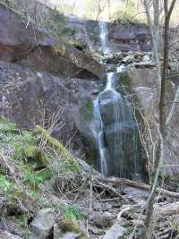 East fork
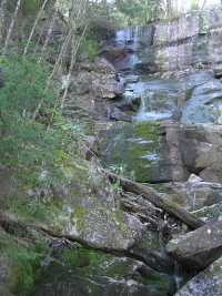 West fork
Dutch Roth
black&white 1929
Tennessee landforms
home
arches
waterfalls
rocks
peaks
balds
sinks
lakes
regions
county
GSMNP landforms (TN/NC)
BSF landforms (TN/KY)
or nearby
lookout towers
 ©
Tom Dunigan
©
Tom Dunigan