Tennessee Landforms -- waterfalls| WGS84 |
| 36.577400 | -82.411400 |
| 36° 34.644'N | 82° 24.684'W |
| 36° 34' 38.6"N | 82° 24' 41"W |
| 17S 373724E 4048921N |
| convert to NAD27 |
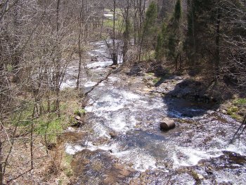
Boozy Creek Cascade 25'
Waypoint: SUF008 36.577400,-82.411400
County: Sullivan landforms of Sullivan county
Locale: private
popup list of
nearby landforms (mileage, bearing)
MAPS
Select one of the following maps to display this waypoint (WGS84).
GPS
Remarks:
Reference & photo: Robert Robbins
Tennessee landforms
home
arches
waterfalls
rocks
peaks
balds
sinks
lakes
regions
county
GSMNP landforms (TN/NC)
BSF landforms (TN/KY)
or nearby
lookout towers
 ©
Tom Dunigan
©
Tom Dunigan