Tennessee Landforms -- rock formations| WGS84 |
| 36.584620 | -84.663830 |
| 36° 35.077'N | 84° 39.83'W |
| 36° 35' 4.6"N | 84° 39' 49.8"W |
| 16S 709005E 4051335N |
| Location uncertain. |
| convert to NAD27 |
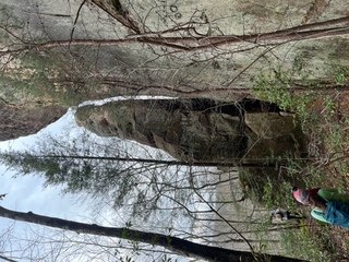
Papaw's Column? 30'
Waypoint: SCR014 36.584620,-84.663830
County: Scott landforms of Scott county
Locale: Big South Fork
popup list of
nearby landforms (mileage, bearing)
MAPS
Select one of the following maps to display this waypoint (WGS84).
GPS
Remarks:
Reference and photo: Wes Hayes
along the bluff line further north from Gage's Tunnel
Tennessee landforms
home
arches
waterfalls
rocks
peaks
balds
sinks
lakes
regions
county
GSMNP landforms (TN/NC)
BSF landforms (TN/KY)
or nearby
lookout towers
 ©
Tom Dunigan
©
Tom Dunigan