Tennessee Landforms -- rock formations| WGS84 |
| 36.542700 | -84.722300 |
| 36° 32.562'N | 84° 43.338'W |
| 36° 32' 33.7"N | 84° 43' 20.3"W |
| 16S 703884E 4046558N |
| convert to NAD27 |
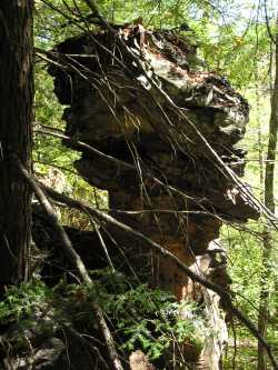
Grand Branch Chimney 9'
Waypoint: SCR008 36.542700,-84.722300
County: Scott landforms of Scott county
Locale: Big South Fork
popup list of
nearby landforms (mileage, bearing)
MAPS
Select one of the following maps to display this waypoint (WGS84).
GPS
Remarks:
Reference: Tom Des Jean (MTSU summer interns w/ GPS, 2003)
off-trail
Tennessee landforms
home
arches
waterfalls
rocks
peaks
balds
sinks
lakes
regions
county
GSMNP landforms (TN/NC)
BSF landforms (TN/KY)
or nearby
lookout towers
 ©
Tom Dunigan
©
Tom Dunigan