Tennessee Landforms -- rock formations| WGS84 |
| 36.562960 | -84.658800 |
| 36° 33.778'N | 84° 39.528'W |
| 36° 33' 46.7"N | 84° 39' 31.7"W |
| 16S 709514E 4048943N |
| convert to NAD27 |
Station Camp N. Chimney 40'
Waypoint: SCR005 36.562960,-84.658800
County: Scott landforms of Scott county
Locale: Big South Fork
popup list of
nearby landforms (mileage, bearing)
MAPS
Select one of the following maps to display this waypoint (WGS84).
GPS
Remarks:
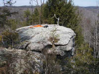
An old trail used to go out to this chimney. All the deadfall (pine beetle)
make it more challenging. You step across to the top of the chimney.
Tennessee landforms
home
arches
waterfalls
rocks
peaks
balds
sinks
lakes
regions
county
GSMNP landforms (TN/NC)
BSF landforms (TN/KY)
or nearby
lookout towers
 ©
Tom Dunigan
©
Tom Dunigan