Tennessee Landforms -- arches and natural bridges| WGS84 |
| 36.608938 | -84.664788 |
| 36° 36.536'N | 84° 39.887'W |
| 36° 36' 32.2"N | 84° 39' 53.2"W |
| 16S 708854E 4054031N |
| convert to NAD27 |
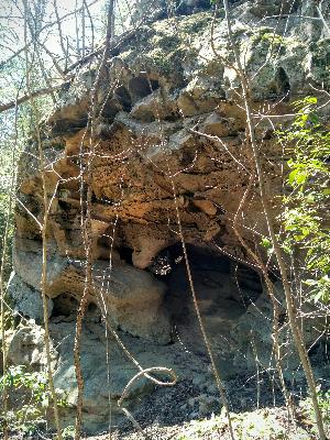
Nancys Tunnel 20'
Waypoint: SCA075 36.608938,-84.664788
County: Scott landforms of Scott county
Locale: Big South Fork
NABSQNO 16S-708854-4054031
popup list of
nearby landforms (mileage, bearing)
MAPS
Select one of the following maps to display this waypoint (WGS84).
GPS
Remarks:
Reference and photo: Tim Smith
Tennessee landforms
home
arches
waterfalls
rocks
peaks
balds
sinks
lakes
regions
county
GSMNP landforms (TN/NC)
BSF landforms (TN/KY)
or nearby
lookout towers
 ©
Tom Dunigan
©
Tom Dunigan