Tennessee Landforms -- arches and natural bridges| WGS84 |
| 36.499400 | -84.653060 |
| 36° 29.964'N | 84° 39.184'W |
| 36° 29' 57.8"N | 84° 39' 11"W |
| 16S 710200E 4041903N |
| convert to NAD27 |
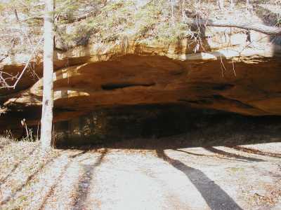
Angel Falls Arch 35x15
Waypoint: SCA001 36.499400,-84.653060
County: Scott landforms of Scott county
Locale: Big South Fork
NABSQNO 16S-710200-4041903
popup list of
nearby landforms (mileage, bearing)
MAPS
Select one of the following maps to display this waypoint (WGS84).
GPS
Remarks:
References: JNAD:TENN-2, WAD:44.18, JNAD 10,John Burns
Just off Grand Gap Loop trail, see GPS
track

Tennessee landforms
home
arches
waterfalls
rocks
peaks
balds
sinks
lakes
regions
county
GSMNP landforms (TN/NC)
BSF landforms (TN/KY)
or nearby
lookout towers
 ©
Tom Dunigan
©
Tom Dunigan