Tennessee Landforms -- waterfalls| WGS84 |
| 35.140479 | -84.596826 |
| 35° 8.429'N | 84° 35.81'W |
| 35° 8' 25.7"N | 84° 35' 48.6"W |
| 16S 718940E 3891266N |
| convert to NAD27 |
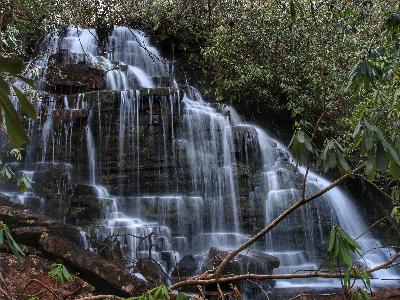
Silvermine Cr Falls 20'
Waypoint: POF022 35.140479,-84.596826
County: Polk landforms of Polk county
Locale: Cherokee National Forest
popup list of
nearby landforms (mileage, bearing)
MAPS
Select one of the following maps to display this waypoint (WGS84).
GPS
Remarks:
Reference and photo: Brian Solomon
Tennessee landforms
home
arches
waterfalls
rocks
peaks
balds
sinks
lakes
regions
county
GSMNP landforms (TN/NC)
BSF landforms (TN/KY)
or nearby
lookout towers
 ©
Tom Dunigan
©
Tom Dunigan